
Featured Wetland Mitigation and Restoration Projects
Columbia County has pursued a variety of projects to improve stormwater management and to resolve flooding issues. This has included development of a regional stormwater management facility that receives water from Bascom Norris Drive and Hunter Creek and provides attenuation and slow release to Cannon Creek. As a part of this project there were unavoidable impacts to jurisdictional wetlands. WSI provided all wetlands mitigation services for this project including delineation, permitting, planting design, monitoring plan development, and planting oversight.
4 Photos
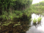
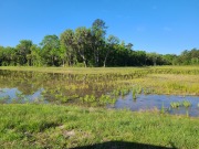
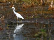
In 2006, the Beaufort-Jasper Water and Sewer Authority, in cooperation with Beaufort County, purchased 600 acres of the Great Swamp north of and adjacent to the existing Great Swamp Effluent Management System. The Mitigation Site was purchased to provide mitigation for wetland impacts associated with County and BJWSA projects and to allow for future expansion of reclaimed water discharges. The site was largely clear cut prior to 1999, leaving fill roads and logging decks at several locations resulting in significant hydrologic and vegetative alterations. WSI prepared a monitoring plan for the Mitigation Site to document baseline conditions prior to site restoration and to quantify hydrologic and biological changes for five years following planned restoration activities. Mitigation Site restoration activities included the clear cutting of pine-dominated areas, removal of the logging fill roads, and tree seedling planting. Pre- and post-restoration monitoring addressed surface water hydrology, surface water quality, vegetation, fish, benthic macroinvertebrates, herptiles, and birds. WSI summarized and reported findings to justify release of mitigation credits.
2 Photos
The dredging of Wadley Pass in the Suwannee River and subsequent placement of spoil materials impacted 4.6 acres of existing wetlands. WSI provided design assistance to the SRWMD to develop construction plans for the creation of 2.24 acres of new wetlands and enhancement of 5.14 acres of adjacent transitional habitat to mitigate for the spoil disposal activities. The design was based on a vegetative and hydrologic assessment of a 3-acre borrow site that was incorporated into the overall mitigation area. The SRWMD submitted the final monitoring report, documenting the success of the mitigation project, to the FDEP in 2012.
3 Photos
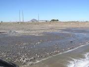
The Va Shly'ay Akimel Project was conceived as an ecosystem restoration project within the hard banks of the Salt River from the Pima Freeway to Granite Reef Dam in Maricopa County, Arizona. In the project area, the Salt River has been impacted through sand and gravel mining operations, channelization and hardbank protection required next to a landfill, the construction of major freeway projects, and intermittent flows. WSI was part of the project team for the Phase 1 design from the Pima Freeway to McKellips Road (3.2 miles). The design included over 400 acres of restored floodplain ranging from open water to Upper Sonoran Desert habitats. WSI led the design of emergent wetland habitats and developed a water balance methodology to estimate water demands for the entire Phase 1 area.
3 Photos